OUTLINE OF HISTORY
OF THE CARPATHIAN BASIN
or
LARGE-SCALE HISTORY OF HUNGARIA
Hungaria; not Hungary. In English Hungary is a time-dependent notion. In the XIXth century it meant the whole Carpathian Basin, 282,870 square km, but the British believed it to be 325,411[a]. Now it means 93,011 sq. km's in the very centre of the Basin. In between it meant the territory on which that state expressed sovereignity whose seat is at Budapest. While the Budapest site means more than the actual place of administration (as we shall see), the history of a mere political entity does not deserve the attention of a physicist.
However, the entity of Hungaria was never anything else than the Carpathian Basin (observe; the term is Latin, the official language of Hungaria). The Carpathian Basin is a unique phenomenon on Earth; and it is uniquely (well, almost) defined. It is not a matter of politics to discuss her history.
It seems that on Dec. 14, 2002, Hungary's & Slovakia's joining to the European Union became a settled matter. The old Union made the necessary agreements with them, the expected date is May 2004, and while the matter in principle still depends on the national Parliaments and on our good behaviour, I think the joining is as good as done.
But then the European Union appears in the Carpathian Basin, and after some years of transition everybody in the Union will have the right to settle down. We do not know if in the next decades great migrations will start or not. We do not know if a migration would be good or not. But, Historia being magistra vitae, this is the proper time to look at the millenia of the Carpathian Basin from bird's eye view.
0. ON THE VIEWPOINT; PRELIMINARY NOTES
A part of the present study (till the end of Sect. 5) deliberately chooses a viewpoint not shared by anybody. Imagine a network of longliving, virtual and ethereal observers in the Basin. (Some society of fairies, in the British sense.) If they are interested at all, they can write such a history. Humans of flesh emigrate/immigrate, kill each other, have propaganda for and against. However our ethereal observers do not emigrate, do not invade and do not die out: they are fixed to the Basin.
Also I want to reach some methodical stationarity. I know much more about XIXth century AD than about XIXth BC. However in itself that is not a reason to write less or more.
This is the first approach. Later I will produce improved versions. I used various texts, corrected obvious errors, misprints &c. if they would have led to self-contradictions. In some cases this was impossible; then I left out the item if it was not very important. Maybe in some cases I was unable to detect the self-contradiction; but then everybody else was too.
Also, I admit that I am not a historian. I am a physicist; a subject of the Basin and member of one ethnic group there. However all facts mentioned are taken from history books of reliable qualities, or Internet texts of professional archaeologists; if fiction works are cited, that is deliberate and the reader is forewarned by a different citation form as {x}. I apologise for trespassing the boundaries of others' disciplines. In spite of my physicist education I am layman in history; however with the exception for my learnt ability to find and compare sources, to detect problems in mathematical logic, and to use computers.
References of form [x] belong to the Appendix Curiosa Variosa.
1. THE BORDERS OF THE CARPATHIAN BASIN
Along some 3/4 of the wind-rose the borders of the Carpathian Basin are mountain ranges. On the West the Basin is bordered by the Alps; on North, East and extreme eastern South by the divides of the Carpathians. On the south the Basin is open; however on the southeastern part the river Danubius (Danube) is a rather substantial border abridged first only by Emperor Traianus in 106 AD. On the southwestern part the boundary is less defined; however in the last 1300 years the exact position is a matter of a co-decision of Croats and Hungarians. With Croats I should discuss this problem in Latin; so let us pass.
On the West the border is not a divide, so in principle the border is not natural. However the Alps is a rather high mountain, so in premodern times western influx was insignificant. In those times the sub-basin around Vindobona (Vienna) was rather the westernmost extension of the Carpathian Basin. Even politically this was valid until 972 AD. The main range of the Carpathians is high enough, above 2,000 m. So it is not simply unique; it is an effective border although the passes can be crossed by small groups. Border controller groups generally can seal the passes effectively; of course transhumating shepherds do not take the passes.
This is generally not observed by foreigners. Ref. {1} is not a counterexample: Brust is a Hungarian.
2. THE GEOLOGY OF THE BASIN
The Carpathians is a young mountain arc, not older than 40 Mys (see later). The Northwestern half of the inside belongs to Gondwana (with African affinity) [b], the Southeastern half to Laurasia (with European affinity). This suggests a more than 180° rotation; and the simplest scheme uses 2 microplates, one originally just North of Africa, one just South of Europe. When Africa and Europe were going to collide, they pushed actually the microplates, and they collided tangentially. So a rotation took place (as with cogwheels). While studies are still going, we do have geological evidences [1].
The intra-Basin borderline is being looked for; but relief maps suggest a quite clear border. Namely, both Lacus Pelso (Balaton, Plattsee) and Lacus Velence lie along the same SW-NE line called the Zagrabia-Darnó line. It would be strange if the borderline of the 2 microplates were not this line, or at least parallel with it. Behind Darnó (c. 47°55' N, 22°40' E, near to Csenger) the borderline becomes rather obscure, but there may be not too much doubt that it reaches the Carpathians near to the source of Tisia Nigra.
Any medium-resolution map shows an interesting "coincidence". Drawing the straight line of the long axis of Lacus Pelso it is also the long axis of Lacus Velence, and this line crosses the Danubius just at the southern extremity of Budapest. Now, this may or may not be an accident.
The location of Budapest is definitely not an accident. In the Basin the Danubius is a very substantial river. Its first permanent bridge, abridging the whole river, was constructed as late as 1849 AD, although at the northern border of the city Aquincum the Romans in the 2nd century AD established a wooden bridge making use of small islets. Now, the most reliable ford of the Danubius is in the southern half of Budapest, with some thermal and medicine springs at that point. The ford was used from the Romans upwards, the simultaneous appearance of springs indicate geological peculiarities, and indeed the site is near to the crossing point of the fault line shown by Danubius and the above mentioned diagonal line. So it is reasonable to say that the site of Budapest was prescribed by prehistoric geological processes. (Budapest is a city of baths, for example.) On the Moon selenological processes formed a replica of the Danubius-Tisia system, the so called Prinz crevasses [2], at Crater Prinz 24.5° N, 44.1° W. While the details of the formation process are not known there so far, for any case the pseudo-Danubius line has a "blob" cca. at the place analogous to Budapest.
3. ON NAMES
For localities, cities, provinces, rivers &c. I use the Latin names, as far as it is possible. This convention is, at least, free of political emphasis. If no Latin name exist, I give English; if English also does not exist, Magyar, or in the lack of it, such as I can find. In the Appendix I give a short, non-exhaustive bilingual list.
There is an important region of the Basin which has a Latin name, so has also an English mirror translation, but that is full with possible misinterpretations for anybody not from the Basin. This region is called Transdanubium. It is Trans Danubium from a viewpoint from the Field of Rákos, traditional place of the national assemblies when each nobleman had the right to attend to [3]. However if we want to avoid such "internal" viewpoint, caution is needed. Namely the Danubius is not linear, not even in first approach, but has two almost rectangular bends, one not far above Budapest, whenceforth the route is almost N-S, the second at the Southern border of the Basin, behind Belgradum [4], where again the route becomes almost W-E. So Transdanubium is synchronously South and West of Danube.
4. THE CHRONOLOGY
If not indicated otherwise, dates are in BC.
When it was possible, I took Calibrated C14 ages. If only uncalibrated ones are available (in older studies) then I utilized the empirical calibration curve (e.g. 500 ys at 3900 BP [5]). Historical data should be compatible with calibrated date and in Greece they indeed are. However the data in this Chapter are not the final word of science & scholarship. But one must start somewhere.
Bw. 40 My and 20 My: Europe-Africa collision process forms the Carpathians, enclosing (parts of) 2 microplates. The history starts.
10.5 My: Rudapithecus hungaricus [g] individuals in the Basin; a few individuals are known from the neighbourhood of the town Rudabánya. (The site was then the shore of a tepid inland sea.) Rudapithecus hungaricus seems to be near to the common ancestor of Homo, Pan & Gorilla (which all should be classified now into Genus Homo), so human history in the Basin started with him [6].
350,000: Erectus individual in the Basin, called Sámuel, at present Vértesszöllôs. According to taxonomy at discovery it is Homo erectus just developing into neanderthal. Modern taxonomy would tell that Homo antecessor is going into neanderthal. Estimated brain capacity is above erectus grade, cca. 1300 cm3.
Bw. 100,000 & 40,000: Jankovichien neanderthal culture (Moustérien or maybe Micocquien), Middle Palaeolithic, west of the Danubius [7].
41,700 (or 44,100?): Szeleta neanderthals (UP) and Aurignacian moderns (UP) start to coexist in Mtn. Bükk. No visible convergence of the two cultures. While the Aurignacians are immigrants from Asia Minor through the Dardanelles & Thrace, the Szeleta culture is autochtonous, descending from Subalyuk Mousterians or maybe from nearby Micocquians. The eponyme site of Szeleta is the Szeleta Cave bw. modern Diósgyôr & Lillafüred (both in Miskolc). Bow & arrow?
35,000: Latest possible date for the SN event forming Veil cloud. (Upper bound is 100,000 ys.) The event is seen from the Basin; transient ozone hole in the Arctic.
c. 30,000: Szeleta culture still exists (further fate is unknown). Northeastern connections (of both cultures) seem probable [8].
25,500: Last known Neanderthal in the Vindija Cave [9], near to Varasd/Varasdin, southern border of the Basin (Croatia since 1777 AD).
18,000: Glacial peak of Würm III. The Basin is a refuge.
c. 12,000: Eastern Gravetties appear.
c. 9500: Start of neothermal conditions, with a transition of several hundred ys. Platonic date of destruction of Atlantis. Mesolithic age starts. So far no mesolithic human bones are found in the Basin.
8700: Younger Dryassic (the last return to glacial climate) ends; Flandria interglacial surely starts. Estimated appearance of Vela SN, precursor of Vela pulsar & Gum cloud [10]. The event cannot be seen from the Basin. South-North migrations are probable, but up to now we do not see them in the Basin. Spring equinox point leaves Leo [11].
7600: End of preboreal
6300: Neolithisation of the Basin under Southern influence (partly colonisation). It seems that Mesolithic hunter/gatherer autochtones (Alpians &/or Cro-Magnonids?) meet dolichokephalic immigrant agriculturalists (almost surely Mediterraneans) [12].
Henceforth I give some entry for each century.
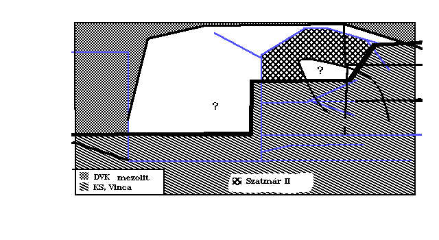
Note: KS line does not separate Körös from Starcevo, but is the Northern boundary of K & S.
LXIst c. | Körös S. of KS line. Neolithic acculturation N. of the KS line. |
LXth c. | Körös culture neolithizes Great Plains mesolithic hunters N. of KS line |
LIXth c. | Szatmár II forms N. of KS line, especially in Satmar. Körös and Starcevo cultures start to be transformed into Protovinca. |
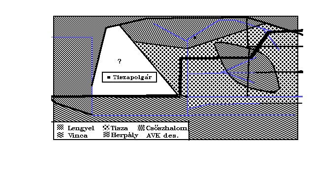
Fig. 1
c. 5800
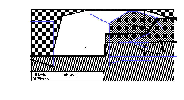
As also on the next 4 graphs, only the center of the Basin is displayed. All borders are schematic. Blue lines are substantial rivers. On the left Danubius. On the right Tisia. Tributaries of Tisia are: from West Sajó. From East, in N-S sequence Samosius, the 3 Chrysii, Marisus and Aureliana [13]. Different patterns stand for different types on neolithic cultures: white is uninhabitated or unclassified.
LVIIIth c. | Thermal maximum |
LVIIth c. | Szatmár II people beat back. Körös culture ceases N. of Chrysius. Szatmár II. develops into Early AVK [14] except in Satmar [d]. |
Fig. 2
c. 5600
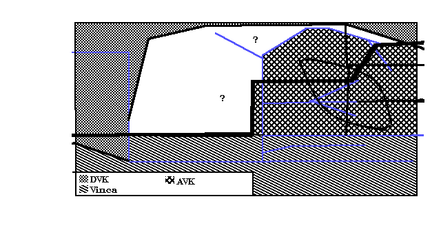
LVIth c. | Protovinca ends bw. Marisus & Chrysius. |
LVth c. | Classic AVK everywhere N. of Marisus. |
Fig. 3
c. 5600
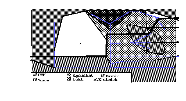
LVth c. | Classic AVK everywhere N. of Marisus. |
LIVth c. | End of Boreal. Esztár Painted Ware starts in Bihar [15]. |
LIIIrd c. | AVK transforms into Szakálhát [16] along R. Tisia S. of KS line, into Bükk (Tiszadob) N. of KS line; Esztár Painted Ware dominates in Bihar. |
Fig. 4
c. 5200
LIInd c. | Early Szakálhát; Bükk I; Esztár PW |
LIst c. | Early Szakálhát; Bükk I; Esztár PW |
Lth c. | Classic Szakálhát; Bükk II; Late Esztár PW. Then Szakálhát transforms into Early Tisza; Bükk III; End of Esztár Painted Ware |
XLIXth c. | Early Tisza; Early Csôszhalom [17]; Herpály from Esztár |
Fig. 5
c. 4800
XLVIIIth c. | Early Tisza; Early Csôszhalom; Herpály |
XLVIIth c. | Classic Tisza; Classic Csôszhalom; Classic Herpály |
XLVIth c. | Classic Tisza; Classic Csôszhalom; Classic Herpály |
XLVth c. | End of Tisza & Herpály tells. End of collective houses. |
XLIVth c. | Copper age starts. Tiszapolgár Culture everywhere [18]. Multitude of small villages. |
XLIIIrd c. | Eastern bands from the steppe violate the Basin. Probably first Indo-Europeans there. Invaders very probably break down the capitol at Tiszapolgár, but intact forces led by the Bodrogkeresztúr chief repel them. One deceased invader chief, Nordic, is buried at Csongrád-Kettôshalom [19]. |
XLIInd c. | Bodrogkeresztúr culture on the East, Lasinja on the West (very roughly, but not even as first approximation, the border is Middle Danubius). |
XLIst c. | End of Lengyel III culture on the West. |
XLth c. | Balaton II on the West, Bodrogkeresztúr on the East. And in Transylvania? |
XXXIXth c. | Balaton II on the West, Bodrogkeresztúr on the East. Bodrogkeresztúr expands: to West above Danubius and to East along R. Marisus (for copper mines?) [20], [21], [22]. |
XXXVIIIth c. | Balaton III on the West, Bodrogkeresztúr on the East. |
XXXVIIth c. | Pécel culture takes over both on East and on West; first unification of the Basin (except possibly Transylvania). |
XXXVIth c. | Baden (bei Wien) is an integral part of the Pécel culture. Activity practically seems to stop at all sites at Bodrogkeresztúr. |
XXXVth c. | Approximate end of significant burial activity in the Tiszapolgár-Basatanya cemetery. |
XXXIVth c. | High activity at Baden. |
XXXIIIrd c. | High activity in Baden. |
XXXIInd c. | High activity in Baden. |
XXXIst c. | End of Atlantic climate. For a far synchronicity see [23]. |
XXXth c. | Peak activity in Baden. |
XXIXth c. | Activity seriously drops in Baden, but one exceptional Tiszapolgár-Basatanya site has become again active. |
XXVIIIth c. | Activity slightly has increased in Baden, while is monotonously declining at Tiszapolgár-Basatanya. |
XXVIIth c. | Activity is fluctuating but weak at Baden and has practically ceased at Basatanya. |
XXVIth c. | Baden is still living but activity is weak. |
XXVth c. | United Pécel culture of the Basin is now disrupted. It seems that: Kurgan (aka Pit-Grave) culture of herders enter the Basin, perhaps through Verecke Pass [24], and advance to the Danubius; from the South agriculturists enter from the Balkan, some even from Asia Minor, Bell-beakers arrive into the region of later Budapest [25] (originally from Portugal). Obviously centers of global forces of the Basin have vanished [26], [27]. |
XXIVth c. | Again tells are starting East of Danubius. |
XXIIIrd c. | Eastern horsemen and local agriculturists at Zók & Vucedol evolving into Nagyrév culture? Pécel survivors found Hatvan culture? In SE Perjámos culture of Balkan & Anatolian agriculturists. At Dunaújváros/Dunapentele-Kosziderpadlás the lowest layer is Nagyrév. Nagyrév culture is agricultural, with tells [28], [29], [30]. |
XXIInd c. | Kisapostag inherits Zók-Vucedol. Aunjenitz culture from the Sudeten occupies the Northwest. |
XXIst c. | The Basin is a mosaic. The disjunct cultures are as follow. Gáta on extreme West around later Vindobona. Aunjetitz in NW, with adjoining Moravian territory. On the West below Danubius (but not in the Buda region + the plains Mezôföld) the Vessels of Lime Inset [31], across the Danubius at the North Magyarád. At Mezôföld, Buda & mirror locations across Danubius (on East) Vatya, successor of Nagyrév. Thence to the North Füzesabony, to the South Perjámos. At the East of Tisia but West of Transylvania Gyulavarsánd [32], at the extreme South Versec-Vattina. In Transylvania proper Wietenberg. |
XXth c. | Magyarád starts to expand to the East. Füzesabony annects Hatvan. |
Fig. 6
Snapshot from just after the annexion of Hatvan Lands. The map shows rather the core areas of the respective countries. Exact borders are not too well defined.
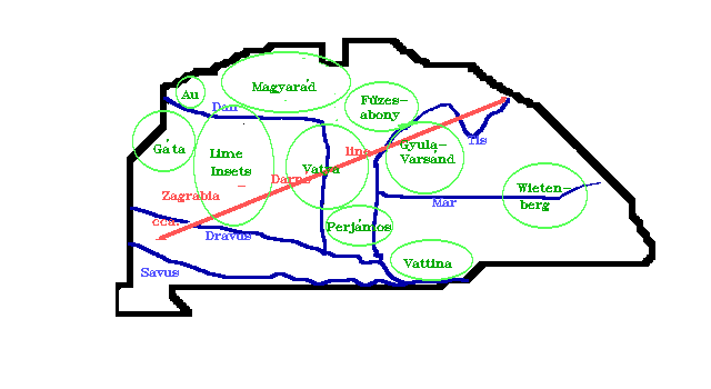
XIXth c. | Magyarád occupies all territory just North of Füzesabony. Kosziderpadlás is already Vatya territory. Eastern tell cultural patterns are strong also in Vatya & Magyarád [e]. |
XVIIIth c. | Royal treasures & badges appear in Gyulavarsánd. Füzesabony & Magyarád expand. Füzesabony expansion is peaceful, but Magyarád's one is not. Magyarád occupies the Lime Inset bridgeheads North of Danubius. |
XVIIth c. | Magyarád crosses Danubius and advances tovards Lacus Pelso. She occupies mainly Lime Inset lands, but also Vatya lands at Süttô, Békásmegyer & Rákospalota. (The two latter within present Budapest.) Vatya & Magyarád apply cavalries (on Gyulavarsánd example?) [33]; Füzesabony-Magyarád cultural convergence. Lime-Insets finally scatter. Treasury burial horizon in the Basin; troubles. Anatolian raiders on the East? |
XVIth c. | Further cultural convergence in the Basin. Magyarád occupies the Kosziderpadlás tell [34]. |
XVth c. | Kosziderpadlás horizon. Tumulus-building herdsmen invade from West through Noricum with bows, arrows & long, narrow swords (charioteer weapons) [35]. Autochtones fight with spontoons [36] and short swords; cavalry weapons (West of Danubius Vatya & Magyarád). Tumulus people win and destroy on large scale. Indo-Europaisation of the Basin? Then consolidation, industrial boom; Urnfield Stage 1. Tumulus & Füzesabony cooperation establishes Piliny culture [37], Tumulus & Vatya the Rákóczifalvi group, Tumulus & Magyarád the Dolny Peter culture. Elsewhere East of Tisia complete Tumulus dominance. All Basin is Urnfield. |
XIVth c. | Urnfield Stage 2. Older Urnfield cultures flourish. Cannelure vessels (cultural contact with Mycene?), until Tisia. East of Tisia Gáva culture. On old Piliny lands Kyjatice, a cultural hybrid of Piliny, Western Urnfield, Gáva & Lausitz. For a while the Basin divides into 3 regions: West, East & North. |
XIIIth c. | Urnfield Stage 3. Massive burials of treasures of type Kurd, because of new Tumulus invasion from outside, NW. Descendants of previous Tumulus wave defend valiantly their homeland against their outside kinfolk but lose [z]. According to a theory this Tumulus wave may be proto-Venetians [39]. Gáva is not disturbed. Reports exist that in this time Argonaut Iason erects 3 altars near to the point where Danubius forks into 2 streams, one to Adriatic, one to Pontus [38]. While Danubius does not fork, at Belgradum & Zimony Danubius takes the Savus, roughly from the direction of Adriatic. But this point is more or less the southern border of the Basin. |
XIIth c. | Urnfield Stage 4. W. of Tisia consolidation of new Tumulus dominance. Gáva on East, Kyjatice on North; on South contacts bw. 2nd Tumulus & Gáva. |
XIth c. | Urnfield 4 flourishes. On the West Vál (including Gellérthegy-Oppidum [40]) and Ság (including Velemszentvid, first real city of the Basin). High-grade bronze industries. First irons appear. "Prescythians", a not quite identified but mounted people starts to invade Gáva, from Southeast, resulting in the Mezôcsát(-Füzesabony) [41] culture. Angyalföld (in Budapest, Eastern shore) gold treasure is buried. Kyjatices look for easily defendable sites. |
Xth c. | Urnfield Stage 5. Prescythian incursions across Danubius. Treasure burial at Pusztahatvan, Mezôföld. Temporary Prescythian dominance at Velemszentvid? Mounted people everywhere. Hallstatt people (proto-Pannons? [42]) invade from Noricum and push back Prescythians across Danubius. Traditional end of Bronze Age but bronze still predominates. |
IXth c. | Mezôcsát culture on East, Eastern Hallstatt on West. |
VIIIth c. | Consolidation on both territories. |
VIIth c. | End of subboreal climate period. Cimmerian (?) invasion East of Tisia. |
VIth c. | According to Herodotos, Agathyrsoi, some kins of Scythians, east of Danubius. |
Vth c. | Celts at the Pannonia-Noricum border. Pannons in Pannonia. Agathyrsoi & Scythians on the East. |
IVth c. | Celts occupy all territories West of Danubius and substantial ones East of. Celtic-Scythian mixed cultures appear. According to Aristotle's (or disciples') De Mirabilibus auscultationibus Argonaut Iason had erected altars at the point where Danubius forks into the river to Adria and into the Ister to Pontus [43]. So in 330 still no significant Greek group has information about the global topography of the Basin [h]. |
IIIrd c. | Celtic incursions against Greek centres (Galatae & others). Very probably the march started from the Basin. |
IInd c. | Boii [44] on the West. |
Ist c. | Rome is interested in the Basin, so first time we get a historical (not archaeological!) snapshot of the whole Basin. Roughly: Boii on the Little Plains (West, both sides of Danubius). Various other Celts West of the Danubius; on the Southwest Illyrians, in the extreme Southwestern corner, near to Venetium & Tergeste Venets. Celtic Eraviscii on the Mons Gellért, so they check the western end of the Danubius ferry/ford. Slightly to the North the Celtic village Aq-inc (Good Waters). East of Danubius on the Great Plains Sarmatian (and Scythian?) tribes. Daci in Transylvania. In the Northern mountain regions various Celtic tribes, maybe some Germans too at the extreme Northeast (it is nontrivial to locate Hercynia Sylva), and Carps (progenitors of Balkan Albanians), the eponymic tribe of Carpathians. Daci invade the West, massacre some Boii, and fortificate the right hand side of Danubius between the Eravisci and Aq-inc. Rome does not like this. |
Ist c. AD | Emperor Augustus orders the army to liberate the region W. of Danubius from Dacian aggressors. Rome takes all territory till the Danubius, organizes Provincia Pannonia, and starts to build the Limes Danubica. (Note that the border of Provinciae Noricum & Pannonia are West of the River Leutha/Lajta.) |
IInd C. AD | Later Emperor Hadrian is Governor of Pannonia at Aquincum. Emperor Traian solves the Dacian problem. Tyrant Decebal kills himself and his federation ceases to exist. |
IIIrd c. AD | Emperor Aurelian evacuates Provincia Dacia; all Roman citizens of Dacia are resettled in the legal successor provinces in Moesia [45]. Pannonia (administratively reorganised as a cluster of a few provinces) remains. |
IVth c. AD | European Huns under Balambér cross River Rha (Etil, Volga), then eliminate the Eastern Gothic state at Danapris (Dnieper). The Migration Period starts. The Roman Empire is split into two, along the Theodosius Line. |
Vth c. AD | Huns in the Basin. Great King Buda (see the city of Buda) takes Pannonia by agreement. He loses the mandate of the Eternal Blue Sky (Kök Tängri), so his younger brother Atilla (Attila, Etele, Etzel, &c; The Bright) kills him. He orders his smiths to hammer an iron meteorite found by the heifer Balmazka into the Sabre [q] of the Blue Sky, and marches to the Atlantic in Gallia. After his slightly early death [46] his German subjects (except for faithful Skirrs, King Edika & Heir Apparent Odoaker [47]) revolt under the leadership of Ardarich of the Gepids. Huns proper retire under leaders Ellac (maybe killed during the turmoil), Dengizic and Irnac, to the plains N. of Pontus. Irnac is first Khagan of Bulgarians after some years [48]. According to Szekler tradition some thousands stop and enter the mountain regions of Transylvania. Dengizic sends the Eastern Goths from the Pontus into the Basin. They enter, and annihilate the recapturing troops of Emperor Avitus at Valcum [49]. The turmoil is strengthened by a Tunguzka-type event at Szilvágy, partially demolishing Savaria [50] and causing substantial damages in Scarbantia. Effective end of Roman culture in Pannonia, although sub-Roman life in Scarbantia continues for some time. After the entry of Eastern Goths they dominate W. of Danubius, Gepids the East. King Odoaker of the Skirrs seems to lose his kingdom, he goes into Rome as mercenary leader, then dethronizes the last Western Emperor, Romulus Augustus, 13 year old son of Orestes, late Chief Secretary of Great King Atilla. Then Eastern Goths led by King Theoderic (born at or near Valcum) leave the Basin, enter Italy and found the Gothic Kingdom. Soon arrive the Langobards. So Langobard dominance W. of Danube, Gepid E. of him. |
VIth c. AD | East Romans occupy Sirmium (Szávaszentdemeter, Mitrovica) as their only prey in the Basin. Arrive the Avars (from the Chinese borders and Mtn. Altai). Langobard-Avar alliance decisively crushes the Gepid Kingdom. Then Langobard-Avar agreement: Langobards deliberately march to Italy, with the full consent of Avars. The second unification of the Basin on Easter Monday of 568 AD [51]. |
VIIth c. AD | Written sources are curiously silent. Avars settle down some Croats at the Adriatic (Adrian Croatia in contrast the older White Croatia in the present Cracovia & Ukraine regions.) That is Roman ecclesiastic territory, so they become Roman Catholic. In the same time Eastern Emperor Heraclius makes an alliance with Serbs (and "Slavic Bulgars" which is a misleading term). Serbs are settled E. of the Theodosius Line, in Eastern Roman territory, so they become Greek Orthodoxes. Start of Serbian-Croatian wars at the southern border of the Basin. In the Basin archaeological evidences suggest first a reorganisation of the Avar Khaganate, then arrival of another group, roughly from the direction of Caucasus. This second (?) wave is intimately connected with the arrival of Danubius Bulgars. So: first Onogurs in the Basin [52]? A medieval court document dates here also the Conquest of Árpád, Prince of Seven Magyars. (See App. B.) The Western border of Avaria is R. Enns [i]. |
VIIIth c. AD | Avaria weakens; details are unknown. Christianity reappears in the Basin. Then the Tudun, the Lord of the Western Marches, revolts, and goes over Charlemagne. |
IXth c. AD | Krum, Khagan of Bulgars, occupies the Avar territories E. of Danubius. W. of Danubius a Frank vassal state of Avars under their Khagan (descendants of the original Tudun?) survives; borders are unclear. Slavs of unclear affinity play important roles: W. of Danubius Prince Pribina, then Kocel. E. of Danube Moravian Rastislav, then Svätopluk [53]. Onogur Turks (r-Turks) are established in the Basin: a diplome of Louis, Emperor of Franks mentions the Marcha Uuangariorum as an Eastern border [54], and a (much later) Slovakian tradition calls Svätopluk "král' Uhorska", i.e. "King of Onoguria". Hungaria evolves from this form [55]. Magyars arrive from the East and they perform the third unification of the Basin in 899 [56]. |
Xth c. AD | The leading clan of Magyars is extending its control over the whole Basin, except the area of Vindobona which Prince Geyza cedes to the Babenberg Prince of Noricum. Finally the Magyar leader is crowned as Rex Hungariae. The Basin is multilingual: as greater blocks on the West there are Franks & Bavarians, on the North the ancestors of Slovakians, on the Northeast White Croats fleeing from Poles, and in the South Croats. The plains and hills of the center are settled by the Magyar, Avar & Petcheneg steppe horsemen, and Transylvania is a mosaic of Szeklers, Magyars, Bulak Turks and "Slavic Bulgarians". Amongst the smaller remnants it is interesting to mention the last villages of Gepids. Croats are majority and independent South of the Savus. (Indeed, the southern boundary is not everywhere the Savus, but it suffices as first approximation.) After the Great Schism practically all the Basin goes with Rome. |
XIth c. AD | After the extinction of the Croatian royal dynasty the King of Hungary is invited, |
XIIth c. AD | The Hungarian King is elected also as Croatian King, but the two Kingdoms remain independent. German migration to the Basin (Saxons), organised by the King of Hungary. |
XIIIth c. AD | Cumans (Western Kipchaks) immigrate from the East and form light cavalry of Hungaria. Mongols from the East occupy half of the Basin for one and half years and almost all of it for some months, with large scale destruction, while the Archduke of Noricum occupies the West. But the Hungarian state recovers and take back the whole Basin. Roumanians start to immigrate into Transylvania from South through the Carpathians. |
XIVth c. AD | The founder dynasty dies out and ten years of internal struggles precede the new system. Hungary will elect all new kings. Doctrina Sacra Coronae: King is only steward of the Kingdom. The Body of the Kingdom (so that of the Basin) is really the Sacred Crown of the Kings of the Basin, and noblemen are members of this Body. (So the Sacred Crown approaches as close our imaginary and ethereal observers as possible for a real, albeit untangible entity. Of course, the Sacred Crown does exist, in 2002 AD in nitrogen atmosphere in a strong glass box. It is intangible in the sense that nobody may touch it but the King and at coronation the proper dignitaries (plus then the Crown touches the nude shoulder of the Queen) [57], [k]) {2}. |
XVth c. AD | Ottoman Turks from Asia Minor take big territories on the Balkan. Serbian and Bulgarian immigration into the Basin; border wars with the Turks on the South. Some Eastern Moravians (Valachs) immigrate from West (Valassko) [58]. |
XVIth c. AD | From the south Turks occupy the central part of the Basin. For one and half century the situation is as follows. The West & North is governed by the Archduke of Austria as elected King of Hungary. On the East (Transylvania + Easternmost Plains) the Prince of Transylvania governs as subject & enemy of the King of Hungary [l]. In the center and on the South the Basi of Buda governs the Turks as their rightful chief and Hungarians as head of the occupying army. (According to different laws [59].) In principle the Basin is one unity with continuous border fighting. Religious schisms also happen (reformation). |
XVIIth c. AD | Border clashes escalate and finally the Archduke of Austria/King of Hungary is able to push out the Turks with a great enough Austrian, Western (German, Italian & English) and Hungarian Army. A few Turkish civilians remain, the majority retires to the South. The Archducal House of Austria is elected as Kings of Hungary "forever". |
XVIIIth c. AD | Almost all the Basin (except the westernmost area) revolt against the Archducal House of Austria. After 8 years of fighting the revolt is put down. The Basin is independent unit, but its King rules from Vindobona, outside the Basin. |
XIXth c. AD | "National conscience". Really it is rather linguistic, but less than half of the Basin has the non-Indo-German Magyar as first language (still it is the biggest group), so linguistic frictions start. Then almost all the Basin goes in revolt against Vindobona. Austria & Russia together win against the Basin but Russians go home. After two decades of weaponless struggles "Austrians" gave in and there is a dual confederation of "Austria" and "Hungary". Here "Hungary" means the Basin + Croatia, and "Austria" means a rather characterless conglomerate ruled from Vindobona. |
XXth c. AD | Two bloody World Wars. At the end of the first Hungary splits from Austria, then the winners give all peripheries of Hungary to neighbouring states. After the second an Eastern (Russian) dominance starts but without settlers. At the end there are two autochtonous states in the Basin, Hungary & Slovakia, + Croatia at the southern border, while 4 states, Ukraine, Roumania, Serbia & Austria have capitols outside but some territories inside. |
XXIth c. AD | Big celebrations (for a year) of the millenium of the foundation of Regnum Hungariae. The Sancta Corona Hungariae is transferred into the House of Parliament, where it is kept as Symbol of the State. Entrance of Hungary & Slovakia into European Union. Borders vanish within EU. |
So much so far.
5. SOME COMMENTS TO THE ANTHROPOLOGIC EVOLUTION OF THE BASIN
This chapter is written without any claim of a review. Only a few comments are made. I feel as if the literature, while big and detailed, would not yet be sufficiently coherent.
First step: the good old times
We have remnants of one species from before man-chimpanzee-gorilla forking; it is Rudapithecus hungaricus, who, really, should be called, of course, Homo hungaricus, since even man-chimpanzee genetic distance is far below of usual genus distances [60]. We are still in Early Pliocene, environment is subtropical in the Basin, no need to specialise for work.
Some years ago we tried to look at the hominisation 10 Mys ago from a viewpoint of the Carpathian Basin [61], but that should be revised in the light of the new findings (e.g. it seems now that neither genus Bodvapithecus, nor species altipalatus exist; they were artifacts of a strong sexual dimorphism). It seems that the Basin in that time was the northernmost peninsula of hominid areals. While there is small chance that important steps would have happened just here, the population of the Basin may have contributed to the gene pool of the later, more tropical territories. It seems that "Rudapithecus hungaricus" either died out or retreated to South. The next hominid is already at erectus stage.
Second stage: just before neanderthals
At a site at Vértessszôlôs L. Vértes at the end of 1960's unearthened remnants of a Homo whom he identified as being in the process of evolving into neanderthal from erectus. Estimated age is 350 ky, estimated brain capacity is 1300 cm3 [62]. According to recent views [63] it seems that we see a (local variant of?) Homo antecessor.
Third stage: neanderthals
Neanderthal findings are numerous in the Basin, see [64] for review and further literature. The center of the Upper Palaeolithic (!) Szeleta culture was within the Basin, although recent views extend Szeletian as far to East as Crimea. Jankovichian W. of Danubius may have been a local variant of Szeletian or not, it is still a matter of argumentation. So we do not yet know if the Basin was unified or not in Neanderthal times.
Hungarian Neanderthals are reported to have had surprisingly modern and symbolic behaviours (mining, collecting curiosa &c.) Maybe Hungarian archaeologists have more than average empathy for them. (Well, they were fellow compatriots from the Basin...)
Fourth stage: palaeolithic modern sapiens
The first anatomically modern sapiens population is an Aurignacian population in the Bükk, not far from the very Szeleta Cave, synchronous with the Szeletians. During the last glacial maximum the Basin was a refuge area, being ice-free. While anthropologic continuity towards Neolithic is not established (neither ruled out), it seems hard to argue against its probability. But they died out {3} (just as Magyars, according to Cavalli-Sforza, see in due course.)
From Neolithic upwards
We have seen in Chap. 4 that in 6300 at least two substantial populations lived in the Basin: Mesolithic hunter-gatherer autochtones being Neolithised via acculturation and Neolithic agriculturists/herders coming up from South. For a while the cultural border is the Körös-Starcevo Line (see Fig. 1), but it does not seem to be an anthropologic border.
Trying to make a guess, we can expect at most 3 different populations at the beginning: Mediterraneans (for the Southerners), Cro-Magnonids (Moravia being near) and Alpians (Alps being in the neighbourhood). Well-classified findings not always verify any scheme, however. Carpathian Basin skull indices start in Neolithic from something 71 and then bracycephalising is almost continuous [64].
Now Mediterraneans have generally skull indices below 76, Alpians above 80 and Cro-Magnons below 80. Furthermore Hungarian authors like to use the label "protoeuropid" for the Neolithic non-mediterraneans of the Basin. This is originally a term of Debec, but using it he meant the dolichocephalic variant ("Cro-Magnon A"). If so, only Alpians can be behind the continuus brachycephalisation (or an unknown process of civilization?). If so, during Neolithic & Eneolithic mountaineer folk is continuously trickling down to agricultural territories, brachycephalising the population.
Anyway, Alpians are very brachycephalic and Alpic populations may very well have existed in the old Carpathian Basin. Presence of strong Moravian Cro-Magnons components within the Basin is a politically sensitive question, being the fundament of Czechoslovakian Dogma the identity of the population just outside and inside. While Czechoslovakia, formed in 1918 according to this dogma, is now dissolved, one of the Bohemian ("Czech") governing parties has still the name "Czechoslovak People's Party". So we do not discuss the Cro-Magnons further.
However, the story may have been simpler. It seems that even isolated populations may have a tendency of brachycephalization under some (unknown) circumstances. A good example is modern Japan [65]; but see also the classical article of Weidenreich [66]. While Mediterraneans do not seem to brachycephalize too much, some Cro-Magnons do. So it is not hopeless to think in a minimal scenario: Maditerraneans & Cro-Magnons + "spontaneous" brachycephalization E. of Danubius. West of Danubius one simply cannot rule out Alpians, for geographical reasons.
Until Bronze Age there are no indications for other groups. Of course, there are Nordics on the Eastern steppe; they are exotic horsemen, maybe softening their horsemeat supper between themselves & horseback. Not even long-range merchants of the Basin have seen a single Mongolian so far.
Nordics pass the Basin outside on the North going to Northern Germany and Scandinavia. The first traces of Mongolian admixture appear with the Scythians (IVth century Greek scientists note the strange, woman-like, appearance in Scythians, but not in Agathyrsoi), and the first really Eastern faces appear with the Huns in IVth c. AD.
6. GENETIC CONTINUITY
We do not know if Basin Neanderthals contributed anything to the latter gene pools. The idea is not absurd, some experts emphasized the "progressive" traits of Central European Neanderthals, and the Vindija specimen is very similar to anatomical moderns. The question (open yet) is the ability to hybridize, and opinions move to and fro in each decade. Mitochondrial DNA does not show any Neanderthal traits, but some Cro-Magnon skulls show a moderate Neanderthal influence in occipital bulbosity, e.g.in Moravia.
Continuity between Late Glacial and Neolithic populations are not established; we do not know the Mesolithic population.
However, Zoffmann [67] claims to see continuity from Early Neolithic till Iron Ages by means of Penrose coefficients [68]. The result is really interesting because in the usual archaeologist interpretations the history of the Basin is full with immigrations, bloodshed, burning and eradications. I do not know the explanation of this contrdiction; but let us remember this in the Conclusions.
7. ON THE POSSIBILITY OF RECONSTRUCTING IDEOLOGIES
It is trivial that it is difficult/tricky/ambiguous to reconstruct the nonmaterial component of social life from archaeology. It is also trivial that we cannot satisfactorily understand past societies if we do not reconstruct this component; and also that some reconstructions are better, some are worse. Instead of intelligent generalities here I give some remarks suggested by the known history of the Basin. Except for the last one the remarks will be sketchy; anyway, prehistoric problems may have arisen from analogous cases, but hardly from identical ones, so too specific details may be futile.
In the examples I suggest to take a two-phase view. Assume first a very good archaeologist from the very far future. So he does not have any written report from the period investigated; but he can get a detailed archaeological information about a definite narrow period before 2003 AD. He collects the data and tries to make a reconstruction of some nonmaterial feature of the society of that period; then come I, and show possible misinterpretations (because I am in historical contact of this period).
Reconstruction of "nationality", which is something in the Carpathian Basin hard to clearly explain to outsiders but may indicate e.g. "first language", clearly does not show up in graves. However about 2000 AD national minority organisations are using their colours. So a minority language school may have an enamelled badge of special colours. However: states generally try to force the state colours (sometimes: too) on schools. So counting badges contains biases.
Similarly, you can count preserved newspaper issues to restore language statistics. But in the Basin between 1945 and 1990 states prescribed the numbers of newspaper copies. Between 1920 & 39 this did not happen, still minorities had worse possibilities than majorities. While this did not happen between 1867 & 1918, small linguistic communities may not have had newspapers. Before 1867 the literacy was not general. The first regular periodical of the Basin at the beginning of XVIIIth c., Mercurius Veridicus, is Latin, while Latin was nobody's first language in the Basin since VIIth c. AD. Also, in Middle Ages the majority of any written documents are in Latin.
Maybe it is easier to reconstruct religions? It may be seen even from burials. Surely, then, archaeologists of the future will be able to reconstruct the religious map of the Basin. For example the future scholar may be able to learn from preserved old books that a Latin cross on a church signifies Catholic church, a double one Orthodox, a cock Calvinist and so on. But Catholic bishopric churches may mimic Orthodox churches (or vice versa).
Maybe kitchen refuses will be more definite? For example, while most Christian religions do not prescribe food preferences (except for temporary fasting periods), Jewish religion forbids the consumption of pork meat from its first formulation, the XIIIth c. BC. So a community with pig bone remnants cannot have been Jewish. Now without going into details we remark that from 1867 AD upwards this is not a rule in the Basin, while it is still more or less a tendency. On the other hand there was never a Catholic command against horse meat; still from 1000 AD for some centuries the clergy was against horse meat in the Basin. The reason of this seeming contradiction was the history of Christian missionary activity. Pagan Magyars in the Xth c. AD ate horse meat in great quantity because they, being nomads, had horses in great abundance. Now, bishops wanted to help the conversion process from 1000 AD, when the State of Hungaria became Christian, by issuing edicts against old lifestyles and one of these was horse meat. Now Hungarian archaeologists found the following pattern. Horse bones in kitchen refuses are indeed rare in the towns of bishops; but they are abundant in other villages & towns even in periods when ratios of Christians were well above 90 % everywhere. So bishops did not/cannot enforce their own edicts against eating horse outside of their seats. If we did not know the religious map, we would reconstruct Christian town of bishops vs. pagan countrysides for centuries.
But assume that the reconstruction is successful and faultless: the archaeologist recovers a petrified exemplar of the complete religious statistics of the Basin (from 1910 AD). This is a great success; and, being Religion conservative, maybe then it becomes possible for the far future to reconstruct some movements of a millenium before 1910 AD. Will it be?
The statistics is detailed. In each county 7 religions were counted, + the remnants as Others. This 8th class is inhomogeneous, but everywhere small. The 7 individually counted religions are Roman Catholic, Greek Catholic, Greek Orthodox, Jewish, Calvinist, Lutheran and Unitarian. A lot are already known about the dogmas of these past religions from off-Basin documents, although Unitarian is rather a Basin religion. Because highly mosaic-type distributions are better understood on colour maps, and the 3-cone structure of male retina prefers 3 dimensional projections, he tries with dozens of such projections. Most give complicated pictures which he puts away for further studies. However he gets one simple pattern which he thinks he can try to interpret first. It is based on the structure of Holy Trinity in the given religions and the pattern is Fig. 7. Blue represents the religions with Western (filioque) religions, meaning that generally in the parts of Europe West of the Basin this structure was believed in the majority in the XIXth c. AD. (Both Father and Son can generate Holy Spirit, although our future archaeologist does not fully understand from the texts what was this.) The actual religions, according to many documents, were Roman & Greek Catholic, Calvinist & Lutheran. Green is the religion characteristic for Europe East of the Basin, the Greek Orthodox. (Only Father can generate Holy Spirit, Son not, so this religion is not filioque.) Finally there was no Holy Trinity at all in two religions, Jewish & Unitarian; they are red. As I told, he gets the simple Fig. 7, and he is so happy that he does not study the data further for a while.
Fig. 7
Religions in the Carpathian Basin (+ in Croatia) in 1910, according to data of KSH (Central Statistical Office) [69], but projected according to the structure of Holy Trinity. Blue: Both Father and Son can generate Holy Spirit ("filioque"); Green: only Father can do it. Red: there is no Holy Trinity (God is One).
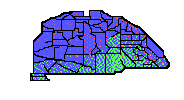
I emphasize that Fig. 7 is not a model; it is made of the data of the official statistics from 1910 AD [69]. But let us continue from the far future.
The simplest explanation needs two subsequent migrations/diffusions. We see a dominant blue background but with two or three disjoint reddish patches. If there were only one around Budapest, he could think an original blue, and an isolated red immigration; he could tell that this latter is analogous with the arrival of Bell Beakers in XXVth c. BC and the analogy would deserve further study. However Fig. 7 shows two stronger and one weaker reddish components: one around the Budapest region, one at far East, and one at extreme Northeast. And red dominates nowhere. Then: Red was the original population mostly substituted by an older Blue wave, very probably from West. The 3 reddish patches show refuge areas where the original Red ideas survived for any reasons; maybe no Trinity was the primordial form of ideology.
Now, in the Blue sea we see a Green wedge from South. The problem is that Green is an Eastern ideology. But our future archaeologist knows about geography. The Basin is relatively open from South. So there was a second migration of an Eastern non-filioque people. They were already more sophisticated. While Blues still could handle only symmetric relations in their theology, Greens were successful with asymmetric ones too (maybe via spontaneous symmetry breaking, as physicists would guess). Clearly the Green immigration was the second and was not able to penetrate the Basin completely; but for a while it got influx, this is the reason for the wedge to be widest at South.
Then our archaeologist observes data for an important immigration wave from Roman Empire times which seems more or less good for the primordial Christian influx (Jesus Christ being roughly contemporary with first Roman Emperor Augustus in very old fragmentary documents), and he founds some monuments commemorating a conquest of the Basin by Easterners roughly a millenium later, albeit some plaques of monuments mention Avars, some Cumans, most Magyars. OK, maybe there were 3 phases, similarly to the Greek Aiolians, Achaieans & Dorians. He is ready for first step; details will come later.
And now comes the written history, still available in 2003 AD. The remarks hence to the end of this Chapter are of course superfluous for everybody in the Basin, but the majority of terrestrial population knows practically nothing about the Basin at all.
On the reconstructed primordial Reds, indeed there is an old Red structure without Son at all, and that is preserved in Judaism. But Red Unitarian is the newest one where Son is only a Fosterson. (This religion is not that of Arius but something elaborated in Transylvania in XVIth c. AD.) The Budapest reddish patch comes from Jewish population, the Northeastern one too, but the Eastern one is mainly reddened by Unitarians.
The Blues were converted in IXth c. AD (Slovaks) and in XIth (Magyars) already in the Basin, or immigrated into the Basin as Christians from West, Northwest & Southwest in various ways & times (and I do not go into details here).
As for the Greens, at the top point of the wedge they are Roumanians continuously immigrating from XIIth c. AD mainly from South, but not where the axis of the wedge is situated. Rather for one and half centuries from 1526 Turks invaded the Basin exactly as the wedge is positioned but their direct traces cannot be seen on Fig. 7 (they were Muslims). However they helped to immigrate Serbs, and Serbs are indeed at the basis of the wedge; but also Roumanians too, who were not helped by Turks.
Nothing is seen on Fig. 7 from the time of the Roman Empire at all, and nothing is directly connected with the Magyar conquest. At the end of XIth c. AD the Basin was almost purely Blue. The Green ideology is older than the Blue, but Christian missionaries in Xth c. came dominantly (although not purely) from West.
Other details belong to specialists. Fig. 7 is real, the suggested interpretation of the far future is reasonable; only untrue in all possible details. Now back to the very beginning of XXIst c. AD.
8. THE GENETIC MAP OF EUROPE; GUESSES FOR THE PREHISTORY OF THE BASIN
A few years ago Cavalli-Sforza, as results of a monumental research activity, published genetic maps of all Europe & adjacent Near East. One version of them is based on the distributions of 95 genes normally possible in alleles. As one observable possibility think about eye colours: in absolutely normal humans the possibilities are at least black, brown, gray, blue, green & yellow, and you can get different percentages regionwise. So the dimensionality of the map is 2 for the independent variables (latitude & longitude) but >95 for the dependent ones.
Now he applied the method of principal components, that is, he chose a restricted number of optimal gene combinations so that it give account of the maximal possible part of the total variation of the dependent ones if the number of the combinations is fixed. He was able to reproduce 73 % of the variation with 5 combinations, which is excellent [70]. I do not give here the 5 sub-maps showing the relative weights of these components, because I am not certain about copyright regulations about them (all the Figures 1-7 are my own, to be sure), but Cavalli-Sforza's article with the 5 maps can be found on Internet [71]. Obviously the simplest interpretation would be 5 waves of immigration into Europe; he made some such interpretations as guesses. Now I am interested mainly on the impacts of the maps on the History of the Basin.
Cavalli-Sforza's Principal Component (PC) 1 explains 28 % of the total variation in itself has a distribution centered somewhere at Near East. His educated guess is that we see the gene combination of primordial agriculturists at Fertile Crescent. They then migrated into Europe and/or their gene combination was reproduced. (Observe that mere cultural imports must not be seen on genetic maps.) Since the Basin does not show anything nontrivial on Map PC 1, we can pass PC 1.
PC 2, however, is interesting for us. In Europe it contains 22 % of the total variation. This PC 2 has maxima at extreme North, North Scandinavia & Samoyed territories, so he thinks it to be connected with the motions of Uralic peoples. While I am sure he is essentially right, as a physicist familiar with continuity equations, source terms and currents, I would suggest rather a negative of the original interpretation, because it is hard to start strong currents of originally Northern populations. Imagine that the original population of temperate & arctic Europe was thin but of a homogeneous & characteristic gene combination. We may call them, by borrowing Debec's anthropologic term without telling that this is just his specific race Protoeuropids. Then from warm and relatively abundant South started any combinations and supplanted the protoeuropids. Of course these currents were gradually eaten up going North, so the result is now the maximum of the primordial component at extreme North. Now see the map of PC 2. The equidensitae are simple, except that the whole Basin belongs to the higher abundance of the Northern component. Then look at our chronologic table about 5500. First a Southern population enters the Basin, but then Northerners, originally Mesolithic hunter-gatherers, also become Neolithic and start to dominate the Basin. Then the result is indeed an excess weight of the Northern component in the whole Basin. So far so good.
PC 3, explaining 11 % of total variation, is centered in the Dnieper & Dniester, and Cavalli-Sforza's idea is that here we see the imprint of the migration of the original Indo-Germanic population. Obviously, language is not so determined genetically, but there was a first, restricted population of speakers of PIE, that showed a chance gene combination and that gene combination left traces in migration. Also it is not absurd to think that this migration immediately followed the first domestication of horse, as a means of faster travel. Indeed, datings of horse bones & glottochronology for PIE (-Anatolians, PIE proper) seem to coincide at cca. 4200. Now we do see traces of an aborted Eastern invasion in the Basin about 4200; it is interesting that the carriers seem to be Nordic. To be sure, the recent distribution of PC 3 is not quite conform with that of the distribution of the Nordic anthropology. Also, the map of PC 3 does not suggest at all that the Basin repelled the first Eastern invasion; but I can tell at least to this second problem that, as we saw in the previous Chapter, a recent map does not have to reflect past time relations at all.
PC 4 (7 % of the total variation) is suggested to be connected with the Greek colonisation; and indeed the pattern is such, except for 2 points to which we return immediately. Then the Basin was rather free of Greeks during its prehistory & history (see again an equidensita just out of its southern periphery), and we know that it was so at least in historic times. The two disturbing points are as follows. First, there is a second maximum in Northern Scandinavia and it is strange to expect close relatives of Greeks in Lappland (albeit there is an author who thinks that Homer's stories happened in the Baltic [72]). Second, the map shows the maximal weight of "Greek genes" until so far East in Asia Minor as the River Halys. Now, this is surprising, albeit not impossible.
And finally PC 5 (5 %) is the weight of "Basque genes". Directly it has nothing to do with the Basin; it is simply on a wide lowland of minimal weight. In itself its second (moderate) maximum in Meotis & Kazaria is not surprising: the territory amongst Don, Volga & Caucasus is a good refuge preserving old gene combinations, and is near to Caucasian languages suggested to be far relatives of Basque (the third maximum in Northern Scandinavia is surprising). However we are close here to the old homeland of Magyars; they (according to texts as old as XIIIth c. AD) lived in Meotis, according to historians were in intimate connection with Kazarians in VII-VIIIth c. AD, and Khazarians completed the shortest, fourth side of their refugium to have built against just them the fortress of Sarkel (White Fortress) bw. the nearest points of Don & Volga about 830 AD.
This is not a problem to Cavalli-Sforza, who believes that Magyars first imposed their language on the Basin, say in Xth c. AD, and then died out or vanished in any other way. (Maybe emigrated to Lappland, the 3rd maximum of the map of PC 5?) I have no suggestion and am as baffled as possible. However I must declare that we here in the Basin see at least some problems. I only tell that the mysterious imposition of ideas must have been very thorough and not only for language. As for language I tell you that now some 50 % of the Basin speaks Magyar, according to the 1980 statistics, and the percentage did not decrease since 1921, when some 2/3 of the territory of the Basin became non-Magyar-dominated [73]. OK, the mysterious, gone Magyars had been very effective. But: in the historical literature of the Basin it is a commonplace the continuity with conquering Magyars back (for reconstructed text, at least) to XIth c. AD. In addition to the reconstructed Ur-gestae, we have 2 voluminous works from XIIIth c. telling the same. I am afraid that to be conform with the hoax/mystification/adoption one should transform away the source population of the Magyar language (let us call them "true Magyars") until the end of XIth c. AD, which would need intensive language courses before.
Magyar language is highly synthetic, with some 30 cases of nouns, with a double declension (slightly polysynthetic) of verbs, with more aspects than in ancient Greek and so on. According to historical experiences about language transfers, even close relative languages lose in such processes much synthetic features (see English as hybrid of Norman Middle French & Anglo-Saxonian). We do know the 2 nearest extant relatives of Magyar: Chanti & Manyshi in Western Siberia (cca. the Tyumen Oil Fields); their conjugation system of nouns is simpler, but verbal declension is similar. One should assume a third small group of Ob Ugors transversing 2500 km, conquering the whole Basin, forcing high degree language courses for the central part of the Basin many manyears for everybody, to learn them also a mythology, and then passing to oblivion before the first written remnants of language (from 1055) and Ur-chronicles (XI-XIIth c). Also, the royal dynasty between 1000 and 1301 was continuous and claimed to be the descendant of the Conquerors.
On the other hand the conquest has not left any trace of the first 5 principal components of Europe's genetics. I must admit that this silence is at least difficult to explain either. The Conquerors must have had at least 2 tumens, 20,000 horse warriors (according to old texts, military calculations and the existence of 7 tribes + subject peoples, recorded by Byzantine Emperor Constantine Porphyrogenetus). Even a temporary existence for 1 (one) generation in the Basin with usual mating preferences for conquerors would have resulted in genetic traces (their minimal number seems to have been 20% of the Basin). Or were they aliens, genetically incompatible with Homo sapiens? For any case, Ob Ugor relatives are not.
It seems to be more cautious to say that the genetic absence of Magyars in nuclear genes demonstrate an inconsistency between the present statuses of history & genetics [74]. At least one of them still needs improvement.
9. CONCLUSIONS
According to established prehistory and archaeology of the Basin catastrophes can be expected in any time in the Basin. Let us see radical changes (mostly catastrophes) so far.
1) There are no traces of Mesolithic population. Is it possible that Palaeolithic population died out or completely evacuated the Basin? While it seems improbable, we do not have any evidence against it.
2) In the Neolithic the population of the Basin is strong enough to turn up the balances. The Basin is its own master.
3) This is so also in Early & Middle Copper Ages. Eastern Nordic barbarians (eating tepid horsemeat on horseback, phew!) try to disturb the peace and superior culture of the Basin, but finally in vain.
4) Then Pécel culture unifies the Basin, maybe first in prehistory. However some archaeologists regard Pécelians as Southern immigrants. Then what have happened with the strong autochtonous Bodrogkeresztúr culture; and with the cultures West of Danubius?
5) At the end of Copper Age archaeologists seem to believe in massive Balkanian & Anatolian immigrations. What have happened with the autochtones? Did they die out? Did they migrate into the Alps? While herders may and can be fierce warriors, plant tenders are generally not. Still Southern agriculturalists seem to supplant autochtones almost everywhere. How?
6) In Middle Bronze Ages Western Tumulus herdsmen run down the Basin twice. Wholesale burning, killing & other destruction. In the same time Füzesabony is successful. What is the speciality of Füzesabony? I heard theories about the speciality of the location Dobogókô, although I am doubtful about; and I can argue for the special location of Budapest. But I never heard even rumours about the specialities of Füzesabony.
7) Then comes Early Iron Age and the population seems still partially continuous from Neolithic for Penrose coefficients [67]. Is this not contrary to the destructions, immigrations and supplantations told so far? Peaceful immigration is a nice thing, but a) it is possible if new lands become usable but even then the new population adds to the old and the extent of continuity goes proportionally down; or b) it is possible if the earlier local population goes down, but then there will be no continuity at all. The measured continuity speaks against a long sequence of radical changes of the population.
8) Then in Iron Ages Venets substitute earlier Tumulus people; Pannons push out Venets, then Celts push Pannons to the extreme South. In Ist c. BC aggressive Dacians massacre Boii. Then Rome establishes peace & prosperity, but Huns push out Romans, Gepids defeat Huns, and Eastern Goths defeat both Romans and Gepids; the last 3 conquests take only 23 years.
9) Then Eastern Goths go to Italy, for a century the Basin is Lombard & Gepid, but Avars come and Lombards leave.
10) Avar state weakens in 60 years, and massive further immigration happens in 50 more years; the new immigrants called either Onogurs, os Late Avars or Early Magyars, according to preference.
11) After 120 years Late Avars are utterly defeated on the West while subjugated by Bulgarians of Khan Krum on the East. Sclavians rise for 90 years.
12) Then the Magyars come, and everything changes forever. They are still here after 1100 years!
13) Fate still keeps try. Mongolians come and kill 6/7 of the country (according to French Dean Rogerius at Varadinum/Nagyvárad/Grosswaradein/Oradea). But immediately afterwards they go out. In 3 years the miraculously restored army of miraculously restored Hungary crushes the troops of Ostmark/Austria and the last Babensberg prince is killed on the battlefield.
14) Then the Turks come for 150 years. They take the center of the Basin, oppress, kill &c. the population, which, at the end, some 4 years after the end of Turkish occupation revolts against Austrian liberators and fight 8 years against.
I stop here. Hungaria and the population of Hungaria seems to behave themselves in an unpredictable way. Populations vanish when we see no reason while they are in quite good shape a few years after massacres. How and why?
In addition, in prehistoric times nobody seems to be able to cross the Basin. Anatolians immigrate from South but do not continue to the Alps or to Moravia. Tumulus waves destroy the Western Basin, become much more peaceful when crossing Danubius, but do not continue (?) to the Balkan. True, it is difficult to cross Danubius; it may take away the strength. But it is no more so in historic ages. E.g. Celts entered from the Alps and went to Macedonia & Asia Minor.
Some inconsistencies may or may not occur in the picture, which is the superposition of orthodox pictures. So our future in the European Union cannot be predicted. In some years anybody from the Union can immigrate. And then? Will the earlier culture vanish as Bodrogkeresztúr vanished against (assumedly) immigrant Pécel culture? Or as Pécel vanished against (assumedly) immigrant Zók? Or, will we flourish eternally as Füzesabony? Or will the Magyar organising force be mythically successful as it is for more than 1100 years so far? Or what?
I am afraid that we do not yet fully understand the History of the Carpathian Basin. According to the present stage of the negotiations we had better understand it until cca. 2010.
ACKNOWLEDGEMENT
I acknowledge illuminating discussions with Katalin Barlai about Copper Age civilisations of the Basin.
APPENDIX A: PLACE NAMES
I use here Latin place names, because the official language of Hungaria was Latin between 1000 and 1841 AD. So each locality which was mentioned even once in official document does have a Latin name.
However not all these names are known to anybody, except a handful of Hungarian medieval experts. So here I give the list of Latin names I use in this document. Others I use in English; or, if no English name exists, Magyar, or, even no Magyar name exists, such as available. An example for this last class is the famous Vinca-Tordos site of the mysterious written documents, resembling the oldest Lagash scripts but earlier, Tartaria [m] (not far from Temesvaria/Temesvár/Timisoara). According to the official name list of the Basin Nomenclatura from 1910 the village had no official Magyar name; Tartaria is Roumanian. (Now its Magyar name is Alsótatárlaka, in Roumania.)
Belgradum | Belgrade |
Chrysius | Cris |
Danubius | Danube |
Marisus | Mures |
Noricum | ~Austria |
Pannonia | ~Transdanubium |
Pelso (Lacus) | Balaton |
Posonium | Pressburg/Bratislava |
Samosius | Somes |
Vindobona | Vienna |
Zagrabia | Zagreb |
APPENDIX B: ON THE YEAR OF MAGYAR CONQUEST
In this Appendix B all data are meant AD, so this will not be repeated.
The official date of the Magyar Conquest is 896, end of April. To make the meaning of this statement, the Hungarian State takes her origin from the alliance of Seven Magyar(s), a tribal alliance, which is not autochtonous in the Basin Hungaria. Therefore the date when this alliance settled down is the start of the precursor of the present State, so its date is a State matter. Most definitely the exact date must have been determined at the end of XIXth c. when the Hungarian Parliament decided to make celebrations for the millenium.
While there was not much doubt that the conquest happened at the end of IXth c., and also that it happened in springtime, the exact year needed a lot of studies. Springtime follows from the knowledge that the Conquest started just from the eastern side of Eastern Carpatian (present Moldava of Roumania, not the Republic of Moldova). On the steppe you can start on horseback when the spring grass is tall enough. Hence you get the second half of April.
The year varied in chronicles bw. 889 and 899. After a lot of scholarly work 895 & 896 seemed most probable. 895 was supported by a Bizantian record of an eclipse, but next year was also possible from interpreting the text. Parliament voted for 896. The end of the Conquest is clearly 899, when Magyars occupy the territory West of Danube. We will not be interested in a few year differences of scholars. However, to see what exactly may have happened in 896, let us see the list of ruling Princes of the Magyar alliance (Hétmagyar, in a chronicle Hetumoger, Seven Magyar(s)) bw. 896 & 1000; from 1000 there are no Princes of the Magyar alliance, the ruling prince Vajk continues as Stephen I, Apostolic (hence the double, "Lotharingic" cross in the coat of arms of Hungary) King of Hungary.
The list is preserved in chronicles, but with variations. I am giving here the most probable list, according to majority of scholars.
1. Prince Álmos of Etelköz. He ruled in the old country, was born in 819, and we are sure about the names of his father & grandfather; for earlier times list vary. He started to rule c. 860. During the conquest (in his 77th year) he either died, or was killed or ritually offered (remember the recorded Khazarian rite: too old or too unlucky Khagans are not good for the welfare of the Nation). According to one chronicle, he could not enter Promised Land, just as Moses could not. The sacred ruler is in special connection with the spirits of the country.
2. Prince Árpád, the Conqueror, 896-907, son of Álmos. The year of his death is the year of the last big defensive battle against Eastern Frank troops in the neighbourhood of the Stronghold of Pressburg. The commander of the Stronghold is Count Pozsony, and in Magyar the city is named after him for the memory of successful defence. There are some ideas that maybe Árpád died in the (otherwise successful) battle; or again a ritual death?
3. Prince Zoltán, his youngest son (maybe the 3 older already had died), 907-c. 946. He was minor when his father died, surely a regency started, most probably a Council of Regents, perhaps the 7 chiefs of tribes. There are good arguments that the Council was led by Prince Szabolcs, very close kin of Árpád (youngest brother or nephew?). The interesting fact is that there are not too much records about Zoltán even in later years. According to obscure records, he governed Transylvania. Most probably the Ruling Prince did not mean too much in the secure Basin, and the 7 tribes lived their own lives with a figurehead Ruling Prince above. (Zoltán is the word "Sultan" in Turkish.)
4. Prince Fajsz, c. 946-955. Only in a Byzantine record; but he was one of the grandsons of Árpád, son of Jutas, 3rd son of Árpád. His rule ends with the lost battle at Augsburg, Bavaria. It seems that significant factions of the Seven Magyar Alliance regarded him usurper. Surely his death was not a ritual one; but he may have been executed. Anyway, there were no doubts about the legality of the next ruler:
5. Prince Taksony, 955-972, son of Zoltán. He takes some (obscure) part in the unsuccessful Augsburg campaign but does not lead it. The leaders are the Transdanubian chiefs Vérbulcsú & Lehel. (The names mean Indulgence by Blood Penitence & Spirit/Breathing.) Taksony's position shows that the family of the Ruling Prince did not have real overlordship until 955. But after the defeat Taksony takes power, depicts the defeat in absurd extent in propaganda, and seems to rebuild central power. He takes his personal pasture lands on the left bank of Danubius instead of the right one, and admits Petscheneg immigrants against possible German counterattack, which, however, does not take place. His own wife is Petscheneg. With his consent Khwarezm merchants establish a marketplace just beside the defunct Roman stronghold Contraaquincum in the Budapest area.
6. Grand Prince Geyza (Géza), son of Taksony, 972-997. He starts German connections. Also he starts Bavarian missionary activity. His wife is Sarolta (White Ermine), Greek Orthodox Christian of Magyar ethnicity from Transylvania.
7. Grand Prince Vajk, on his baptismal name István (Stephen), 997-1038, from 1000 Rex Apostolicus Hungariae. His wife is Gizella, Bavarian, sister of a German Emperor.
So the century between Conquest and Apostolic Kings of Hungaria is composed of two halves. In the first half the Ruling Princes did not seek connections with the West and were continuously weaker and weaker. In the second half they reestablished their central power and then started to establish Western connections. However observe that there are practically no Hungarian records about the Princes bw. 907 & 955 (chronicles tell generalities about Zoltán and nothing at all about Szabolcs & Fajsz). Still, the 101 years can be conveniently filled with the 5 Ruling Princes, so maybe no names are lost.
The picture is coherent, and it would be hard to doubt that Hungaria's military power substantially increased at the end of IXth century. Still, there is a reliable source putting the Conquest to the VIIth century. This is a chronicle called the Illustrated Vienna Chronicle. It is a Hungarian product from 1374, certainly made and checked in the Royal Chancellery. Namely, a daughter of Louis the Great of Hungary (an Angevin; 1342-1382), Katherine, was born in 1370. After 4 years negotiations started with the French court about a marriage between Katherine of Hungary and Louis de Valois, Prince of Orleans. This unique, heavily illustrated chronicle was sent to France to inform the French court about the history of the nation of the bride-to-be. This is the reason why it is sure that the Royal Chancellery checked the product.
Now I am going to translate its crucial part to English through Magyar. The original Latin can be checked in [75]. It is in Chap. 26: "Anno Domini the six hundred seventy seventh year, hundred four years after the death of Attila, King of Hungarians, in the time of Constantine III Emperor, and Pope Zachary, as it is written in the chronicles of Romans, the Hungarians came out of Scythia second time. [Then comes a short genealogy up to Álmos, and another, backward, from Álmos to Noah; finally from Álmos to Taksony.] In AD six hundred seventy seven, after hundred years of the death of King Attila, in the days of Emperor Constantine III and Pope Zachary on vulgar language the Hungarians i.e. Huns, in Latin Ungari again entered Pannonia. ... While in their camps, they determined to elect seven captains and to form seven armies...Among these captains the richer and mightier was Árpád, son of Álmos...".
So there is no doubt that this event is the same Conquest which is put to 896 by other sources. But what about Year 677?
It cannot be a misprint. The date is written two times, with words, not clumsy Roman numbers, Byzantian Emperor & Pope are correct for 677, and the list gives only 5 princes between Attila and Árpád. The compiler did meant the second half of VIIth century.
The Royal Chancellery ran then into another problem. Let us put Conqueror Árpád to 677. In the chronicle his grandson is Prince Taksony, whose grandson is Stephen, so in the fifth generation we are up at 1000. The chronology is impossible. Either the Conquest was in 896 and no generation is lost or it was in 677 and cca. 6 generations are lost. Still, the Vienna Illustrated Chronicle chooses the Long Chronology.
Now, observe two independent facts. One: Bulgarian official chronology puts the foundation of Danube Bulgaria to 681, by Khan Asparuch, second son of Khagan Kovrat of Pontus. (By this genealogy, of course, Asparuch is descendant of Irnac, son of Atilla.) Two: Hungarian archaeologists detect the arrival of a new Eastern population into the Basin from the direction of Caucasus in c. 680 (called loosely Later Avars). So, in the neighbourhood of the Basin Eastern migrations happened about 677, and at least one nation entered the Basin. Still, the Royal Chancellery-supervised Chronicle tells that this was the startpoint of Hungarian state.
A Saxon monk Widukind, close kin of the German Emperor, wrote at the end of Xth c. AD the History of Saxons. Volume III, Chaps. 17 & 19 tell something strange: "...the Dalemintzi [Wetern Slaws along Middle Elbe] cannot bear his [Prince Henry of Saxony's] attack, hired against him the Avars, this hardy nation, which is now [Xth c.] called Hungarians [Ungarios] ... Since Charlemagne defeated the Avars and pushed them East of Danube, and erected mighty fences around them, this stopped their usual destructions. These fences were annihilated during Arnulf [Emperor, end of IXth c.], and opened up for them [for Avars] the way of destruction, because the Emperor quarreled with Zwentibold [Svätopluk], King of Moravians. Until now depopulated areas and strongholds show, what destructions and damages were caused by them [Avars] to the Frankish Empire..."
The author does not distinguish Avars (in the Basin independent 567-803) and "Ungarios". He, in the Xth century, has not yet recognised a new Eastern population, although he is a close kin of the Emperor fighting them. However he detects the "change of names". Who were Widukind's Ungarios? Surely not Magyars, the names are very unsimilar, but some Hungarians. Maybe Ungarios=Onogurs? Was the Onogur Conquest in 677? Onogurs & Bulgars are both r-Turks and Bulgars appeared only 4 years later.
Beware: there will be still an Appendix C (but without References).
NOTES AND REFERENCES
[1] You can find ample references in Sz. Bérczi, B. Lukács & K. Török: Snouted Spherules in the Carpathian Basin and in Antarctica. KFKI-1999-09, whose abridged version appeared in Ant. Meteorites XXV, 175 (2000)
[2] Gy. Hédervári: ***. Sky and Telescope, Oct. 1969
[3] During 1541 & 1686 AD Buda & Pest were in Turkish hands, so Parliament sessions were held at Pressburg. In this time some Slovakian texts use the term "prespursky rákos" (see Refs. [55]), i.e. a "rákos" at Pressburg. Rákos is an assembly at Rákos, even if it is anomalously held not at Rákos. (In Polish "rakosz" is a mass disturbance of nobility.) Now, you may take a modern map of Budapest to see that the Field of Rákos is not a mythology: lots of place names appear starting with "Rákos". (It seems that the Field of Rákos was along the Rákospatak, Creek of Rákos, in District XVI.) For example, District XVII is Rákoskeresztúr; Kereszt-úr is Lord of the Cross, i.e. the Saviour. Remember this at the name of Bodrogkeresztúr. Also note that Pressburg's original Slovakian name is not Bratislava but Presporok. (The Magyar name is Pozsony.)
[4] Belgrad, Biograd, Beograd, Balgrad all are Slavic forms for White Castle, some royal/ducal capitol. In Hungarian Latin it is simply Alba, in Magyar it is Fehérvár. E.g. the city of coronations is Alba Regia; in Magyar Székesfehérvár, i.e. the White Castle of the Seat (of the King), and the same in German: Stuhlweissenburg. In Turkish Ustolni Belgrad, the same but in Serbian. Now, Belgradum at the confluence of Danubius & Savus is originally Nándorfehérvár, The Ducal Place of Nándors; Nándors are Onogundurs/Onogurs. Remember these Onogurs.
[5] Calibration is quite an industry now. But if you are not interested in details, you may turn to C. Renfrew: Before Civilisation, Penguin, Harmondsworth, 1976. It discusses calibration and gives an empirical curve for average. Of course there are times when the empirical curve has "kinks".
[6] The best Rudapithecus bones actually come from women. Should then I write here "...started with her"?
[7] Henceforth for a while I refer to B. Lukács: The Lapedo Child, The Szeleta Men, and the Convergence to Leading Cultures. http://www.rmki.kfki.hu/~lukacs/lapedo.html, discussing Carpathian Basin Neanderthals, especially the Szeletians, with ample literature.
[8] Szeleta has a Northern appendix/twin, Jerzmanowice. You can find a suggestive map at ***: Human Evolution. http://tyr.ioa.ucla.edu/CSUN/Anthro150s99/EUP/tsld002.htm
[9] I. Karavancic: The Early Upper Paleolithic of Croatia. Mediterranean Prehistory Online, http://www.med.abaco-mac.it/issue001/articles/doc/004.htm
[10] G. R. Brakenridge: Terrestrial Palaeoenvironmental Effects of a Late Quaternary-Age Supernova. Icarus 46, 81 (1981)
[11] With the end of Younger Dryassic glacial way of life was disrupted. (It was founded on seasonal migration of reindeer and such.) So old wisdom passed away, old harmony vanished. Note that this is just the same as astrology tells: when the spring point left the zodiacal sign Leo, ancient age of wisdom ceased and discord appeared (Leo being the sign for wisdom, regal power &c.). What is interesting and would deserve some discussion is that astrology could date this event quite well centuries ago (because only the cycle time of precession was needed for this, approximatively known already for Hipparchus), while archaeology knew nothing about the glacial chronology until the Milankovic calendar a century ago, and no correct time for the end of glacial until the advent of C14 chronology. But of course if postglacial troubles started just when at the autumn equinox celebration the population noted that not the asterism Leo crossed the meridian at midnight but Crab, they may have done a superstitious conclusion about Cause and Effect and they remembered this.
[12] Now a lot of scholars doubt the existence of races at all. It is a matter of definition. Still, some populations are dolichocephalic in average, some brachycephalic, some tall, some not. In average people of the Alps have quite short (brachycephalic) skulls.
[13] Aureliana is a negligible creek in 2002; it reaches Tisia at Ada. It was substantial in Neolithic. Hungarian name is Aranka, from arany=aurum. Interestingly enough it is Aranca in Neo-Latin Roumanian.
[14] AVK means Alföldi Vonaldíszes Kerámia, so Great Plains Linear Pottery. Alternative maccarony abbreviation sometimes used is ALP (A for Alföld), and there are circumscriptions. Here I use AVK. DVK is the counterpart for Transdanubia, Dunántúl. DVK is cosmopolitan while AVK is unique for the Basin. But Danubius is cosmopolitan while Tisia is born in the Basin and is taken by Danubius in the Basin, at Titel [n].
[15] Not Bihar of India, but a county. In Hungaria Comitatus.
[16] I cannot help about the very Magyar names. This is still a moderate one. At least you now can see why Calvin (W. H. Calvin: The Ascent of Mind, Bantam Book, 1990) propagated the idea of Fermi & Szilárd that Hungarians are interstellar aliens. Take John von Neumann as an example. His family were noblemen in Margitta. If you cannot find Margitta on a map of modern Roumania, then it still may help that it is on the territory of Middle Bronze Gyulavarsánd country; and of course Johnny von Neumann could have pronounciated the sequence Gyulavarsánd, Füzesabony, Vatya, Nagyrév, Magyarád in 4 seconds.
[17] Csôszhalom is just opposite to Mt. Tokaj, across Tisia. Mt. Tokaj is now famous of its heady wine. In Neolithic the hill did not have grape; but it still would be a good guess. Namely Tokaj wine is good because the soil coming from volcanic lava, Now, Tokaj is the second youngest volcano of the Basin, it was alive 5 My ago (the youngest is Hargita, the sacred mountain of Szeklers, 500 ky old, still with mud volcanoes and gas emission), so its obsidian is of excellent quality. Csôszhalom is an artificial capitol (as Brasilia), for the supervision of obsidian mines. Csôszhalom is within the modern settlement Tiszapolgár; remember this.
[18] Tiszapolgár society was somehow nontrivial. See a lecture of Katalin Barlai, coming soon, with its abstract on the Internet as Katalin Barlai: Micro History in "Basatanya I", a Copper Age Cemetery. http://www.folklore.ee/SEAC/SEAC_teesid2.htm.
[19] J. Makkay: A tiszaszôlôsi kincs. Gondolat, Budapest, 1985 and citations therein.
[20] From Bronze to Iron Ages in the Basin archaeologist F. Kôszegi, A történelem küszöbén, Kossuth, Budapest, 1984. tells an interpretation of the story. Compare it with the next two too. Unfortunately all 3 still used uncalibrated ages, so I pushed back the beginning with 5 centuries and the end with 2.
[21] Gy. László: Vértesszôlôstôl Pusztaszerig. Gondolat, Budapest, 1974.
[22] E. Ferenczy: A magyar föld népeinek története a honfoglalásig. Gondolat, Budapest, 1958.
[23] Sumerians had a local Flood which then went even to the Bible. Correcting some "mistypes" one can get its date from the Sumerian King List, an old chronologic book whose final edition appeared c. 1600 (of course BC); we get the date 3015±60 (B. Lukács & L. Végsô: Altorientalische Forsch. 2, 25 (1975)). Just after the Flood & reconstruction in northern Kish starts the first named and dated King of the oldest factually verified dynasty (Kish I) of World so far: Ga...ur. (The middle syllable was unintelligible even in 1600 of course BC.)
[24] It seems that many Steppe Peoples use Verecke Pass; indeed it is at convenient place. There are lots of patriotic Magyar poems and songs about it. But there are many passes. The diametrically opposed one is Dévény Pass (Devin/Dévény is now a suburb of Pressburg/Bratislava); it was used by some Westerners and there is one famous poem about it.
[25] Bell-beakers are cosmopolitan, and generally like commercial centers. But there is still no Budapest! Remember Note 2.
[26] Here I confronted Literature [20]-[22] with I. Ecsedy: http://www.museum.hu/search/museum.asp?ID=906 A and with [27]. It seems that the beginning of Bronze Ages was chaotic and still is for us. Also, the fact that the first Zók excavation was executed by the occupying Serbian army and the finds were classified as war secrets may get its explanation is we accept the story that the new Hungarian-Serb border was drawn in 1920 according to the border between Körös & Starcevo cultures.
[27] I. Bóna: http://www.garabonczias.hu/dolgozatok/bronzkori.shtml
[28] Another 3 texts are useful. The first is I. Bóna: http://www.garabonczias.hu/dolgozatok/bronzkor2.shtml.
[29] Ildikó Katalin Papp: html://www.garabonczias.hu/bronzkor1.shtml. Magyar given names are sometimes unique but Ildikó is international, only you may not recognise it. Ildikó of the Burgunds was the last and fatal wife of Atilla, Great King of Huns and she is in Wagnerian operas. Only: the Burgundian form is Kriemhilde.
[30] Mária Novotná: http://phil.muni.cz/archeo/sbornikm2/Novotna.html
[31] Sorry, but they are really called The People of Vessels of Lime Inset.
[32] Now you can understand Note [16].
[33] Hussars bw. Tisia & Danubius will be again commonplace in Middle Ages; but were there also in Roman times: the Sauromat Jazyges.
[34] Some authors prefer Vatya overlordship until the end. Magyarád artifacts at Kosziderpadlás indeed may come from presence of Magyarád forces jointly fighting Tumulus army as well.
[35] Chariots have not been found so far. But we know that some kinds of chariots were employed in Indo-European migration to Denmark. So the Basin got them in billiard fashion. The Carpathians shield us somewhat: remember Chernobyl when radiation was high in Poland, moderate in Austria and quite low in Sardinia and Hungary.
[36] I could write "hand ax" or even "tomahawk", but it seems that "spontoon" is the mirror translation of Magyar "fokos" and Slovakian "valaska". Magyar "fokos" is a par excellence horseman weapon and in peacetime it was used by mounted herders; the weapon is "valaska" in Slovakian and it is used by shepherds as we shall find.
[37] Bóna observes [27] that the Füzesabony country and only that is not excited when the Tumulus people is going to come. Were they invited? Did Füzesabony people rely on their own verbal power? Or what?
[38] These reports first are from mythographers and poets, see e.g. {3}. But also Aristotle of Stageira (definitely for the 3 altars). We return hither in Note [43].
[39] Today's Hungary has a few thousands of Vends, but they speak a Slavic idiom. But they live in the corner nearest to Venice. So: maybe Venets are the first actors of the 8000 year story whose names are still alive in the Basin.
[40] Gellérthegy-Oppidum must have had a Latin name, because it was evacuated by the Eravisci just in the years when Romans came and remained a cultic center in Roman times. But the name was never used in Middle Ages. The original Hungarian name seems to be Mons Kelen; but in 1046 pagan rebels put Bishop Gellért (Gerardus) of Venice into a barrel and kicked it down from the hill, because they thought him to be in plot with bad King Peter I Orseolo (originally also from Venice) [o].
[41] Look: still Füzesabony is important. Does Füzesabony survive everything?
[42] There are no Pannons in XXIst century AD; but there is a Pannonia.
[43] It is unimportant here if Iason really came to Zimony or Belgradum. The important thing is that the story of Danubius forking still lives in science in IVth c.
[44] The name is preserved in Bohemia, but now Bohemians insist to call their country Czech Republic. What is the name without Republic?
[45] The Theory of Daco-Roman Continuity (official in Roumania until Dec. 1989 AD) knows otherwise. (See e.g. C. C. Giurescu (ed.) Chronological History of Romania. Editura Enciclopedica Romana, Bucharest, 1974. But there are written documents of the evacuation and precursors of modern Roumanian language are found on inscriptions in Southern Balkan.
[46] On the wedding night with Ildikó he got a stroke. See also Note [29].
[47] Beware: he will be King in Rome in 22 years!
[48] Priscus Rhetor reports from 448 AD that there was a prediction: with the death of Atilla the Empire ceases but youngest son Irnac founds another. Correct.
[49] Sági K.: in Régészeti barangolások Magyarországon. Panoráma, Budapest, 1978, p. 101
[50] It impacted on Sept. 7, 456 AD, late evening. Remnant crater seems to be the half one at Szilvágy-Patkó. Half of Savaria was demolished, serious damages in walls in Scarbantia, see e.g. A. Arday & al.: Would We Detect a Semi-Recent Impact of an Icy Tunguzka on Clay? PIECE’99, ed. Y. Miura, Yamaguchi, 1999, p. 1. St. Severinus quelled a disturbance at the end of Mass, writes his biographer Egyppius (d. 511 AD).
[51] I. Bóna: The Dawn of Dark Ages. Corvina, Budapest, 1974.
[52] Hungaria comes directly from Onoguria, as we shall see. On Ogur is Ten Arrow, so Ten Tribe in Bulgarian or -r Turk (of course no plural after definite numeral). Onogurs' name would be Onoguz in Common Turk.
[53] Maybe Svätopluk rules the area bw. Danubius & Tisia. It is not clear which is his original homeland: Southern Moravia along the right hand tributary Morava of Danubius, or Northern Moravia along left hand of Danubius.
[54] A diploma of Eastern Frankish Emperor Louis from May 8, 860 AD. He donates some lands to the Mattsee Abbey. One border of the land is at "Uuangariorum marcha", c. the March of Vangars/Ungars. Monumenta Germaniae Historica. Diplomatarium Germaniae ex stirpe Karolinorum I, ed. P. Kher, Berolini, 1934, p. 145
[55] This comes from a (more or less) Slovakian calendar of the city Zilina for the year 1708 AD, edited by D. Krman (Lutheran superintendent). See in I. Käfer: A miénk és az övék, Magvetô, Budapest, 1991, and I. Käfer: Országos Széchényi Könyvtár évkönyve 1972, p. 245. Uhorsko, the modern Slovakian name for the whole Carpathian Basin, is the endproduct of quite regular phonetic changes in Slovakian from IXth c. AD from an original *Onogursko. As an analogy consider the word for "mushroom": in Magyar "gomba", in modern Slovakian "huba". The origin is the same, it seems that early Magyars borrowed the word from proto-Slovakian. But in Slovakian evolution g->h happened in many cases, and nasal o or on-, om- -> u was regular (cca. in Xth c. AD). Interested readers may consult monographs of Slavistics.
[56] Henceforth standard Magyar and Slovak history books tell the story quite similarly in main features, so no need to cite them.
[57] The King may be female; Hungarians can crown a female with the Holy Crown without problems. This would have caused very big technical problems in Early Medieval Ireland [p], while Irish think this to have been possible in more ancient times {4}. An example is Maria Theresa (1740-1780), Rex Hungariae. Of course the Crown was on her head. As far as I know, the Crown did not touch the nude shoulder of her consort, Francis of Lorrain.
[58] They were predominantly shepherds in Valassko, Eastern Moravia. Their spontoons are called "valaska".
[59] If somebody does not believe this, he can consult with the book Klára Hegyi: Egy birodalom végvidékén. Gondolat, Budapest, 1978. Turkish peasants did not settle; towndwellers only in the quantity as needed for the garrison cities.
[60] M. C. King & C. A. Wilson: Evolution at Two Levels in Humans and Chimpanzees. Science 188, 107 (1975); Elizabeth J. Bruce & F. J. Ayala: Humans and Apes Are Genetically Very Similar. Nature 276, 264 (1978)
[61] Sz. Bérczi, B. Lukács & K. Török: The Carpathian Basin in Hominization. In: B. Lukács & al. (eds.): Carpathian Basin: Steps of Evolution, KFKI-1993-21, p. 68
[62] L. Vértes: Discovery of Homo erectus in Hungary. Antiquity 39, 303 (1965)
[63] J. M. Bermúdez de Castro & al.: A Hominid from the Lower Pleistocene of Atapuerca: Possible Ancestor of Neanderthals and Modern Humans. Science 276, 1392 (1997)
[64] I. Kiszely: A Föld népei. Európa. Gondolat, Budapest, 1976.
[65] Makiko Kouchi: Geographic Variations in Modern Japanese Somatometric Data: A Secular Change Hypothesis. http://www.um.u-tokyo.ac.jp/publish_db/Bulletin/no27/no27007.html
[66] F. Weidenreich: The Brachykephalization of Recent Mankind. SW J. Anthrop. 1, 1 (1945)
[67] Zsuzsanna K. Zoffmann: Anthropological Sketch of the Prehistoric Population of the Carpathian Basin. Acta Biol. Szeged 44, 75 (2000)
[68] Penrose coefficients are roughly the metric tensor elements in a quadratic form for expressing distances of populations. The trick is to normalize the differences of averages with the standard deviations of the populations, and to form a quadratic average for different characteristics. So, if the distance is significantly above 1, the two populations are really different. The significance conditions are essentially those for chi2 tests.
[69] ***: ***. Magyar Statisztikai Közlöny, New series 42, 6 (1912)
[70] L. L. Cavalieri-Sforza: Genes, peoples, languages. PNAS 94, 7718 (1997)
[71] ***: ***. wysiwyg://35/http//www.geocities.com/racial_myths/genetic_variation.html
[72] F. Vinci: Omero nel Baltico. F. Palombi, Rome, 1998
[73] Z. Dávid: A magyar nemzetiségi statisztika. Valóság 1980/8. p. 87
[74] Ornella Semino & al.: The Genetic Legacy of Paleolithic Homo sapiens sapiens in Extant Europeans: A Y Chromosome Perspective. Science 290, 1155 (2000). Since this article sees something in Magyars, and Cavalli-Sforza is 16th author, does this mean revision of his 1997 opinion or does not?
[75] I. Szentpétery: Scriptores rerum Hungaricarum tempore ducum regumque stirpis Arpadinae gestarum. Budapest, 1937, Vol. I, p. 239 sqq.
{1} S. Brust: The Brokedown Palace. Ace Fiction Books, New York, 1986
{2} B. Kurtén: The Dance of the Tiger. University of California Press, Berkely, 1995. The idea there is that Neanderthal women preferred the males of neotenic H. sapiens sapiens (they simply seemed them cute), but the mixed matings were sterile. Lots of unsatisfactory explanations exist for the lack of extant Neanderthal mtDNA.
{3} The most detailed is of course Apollodorus: Argonautica, but in it the Danube part is very short. However it also invents a complicated river route between the mouth of Danubius & Adriatic.
{4} K. Taylor: The Sorcerer's Sacred Island. Ace Books, New York, 1989
APPENDIX C: CURIOSA VARIOSA
Here I do not give references. These comments are rather stories only, for the amusement of the reader. Still, all stories are either true or at least a part of tradition.
[a] They confused Hungary & Croatia, as we generally do with England & Scotland. But they had one excuse: the double state Hungary & Croatia had no name. In Hungary the loose but official formula was (e.g. in official statistical publications) that the dual state (beware; not Austria-Hungary which in Austria was not called Austria-Hungary because the name Austria was opposed in Austria) was called Hungary with Croatia & Slavonia (beware: Slavonia is not Slovenia, neither Slovakia, and I will not tell here what it is, because that is a matter of Hungarians & Croatians purely), while in Croatia it was called cca. Croatia-Hungary.
[b] From the Permian of Hungary petrified araucaroid stems are known (W. of Danubius); taxonomic names are Dadoxylon and Ullmanites. If one wants to check this, in the building of the Hungarian Geological Survey H-1143 Budapest, Stefánia út 14. some fragments are kept for display.
Now, Araucariales are "the pine trees of the southern hemisphere", so the southern counterparts of northern Pineales; otherwise they live in similar niches, see e.g. the "Norfolk pine". And still, 250 My old Ullmanites and Dadoxylon are in the Basin, but only W. of Danubius.
[g] David Begun believes that she was simply a local Dryopithecus brancoi. Maybe so, maybe not; but we like her, being a compatriot.
[d] Yes; Comitatus Satmar is generally conservative. See a story later about Freiherr Haynau, Ret. General in the Satmar Assembly.
[e] Magyarád is in Slovakia, If one is curious about its Slovakian name, it is Mad'arovce. The Magyar and Slovak names both mean that it is a Magyar town.
[z] Here comes the Satmar story. Freiherr Haynau was the Austrian C-in-C. in 1849 AD when Russia & Austria won against Hungary, and afterwards he headed the military courts. Lots of Hungarian officers were executed, including 13 generals (and 9 by hanging!). Then on the last day of his office somebody informed him that next day he would be recalled. He became very, very angry; ordered the courts to assemble and deal with the remaining more substantial accused; they were some 120, and all got capital sentences, of course. Then he pardonned them all.
Now comes the Satmar story. At his retirement he got some lands from the Emperor in Satmar. When the Satmar County Assembly was resuscitated in 1860, he got indigenatus, cca. the assembly naturalized him (since he was from a foreign nobility, and having lands in Satmar). In next February the Emperor issued a constitutional order incorporating the Basin into the Empire. For Hungary (& Croatia) the order was completely absurd, impossible and lawless. So the county assemblies vehemently protested, and in the Satmar Assembly Retired Feldzeugmeister (I do not try to translate this rank) Haynau, brandishing his sword, told: "We Hungarians will demostrate to the Austrians, that we will not permit to violate our ancient rights!" Rather an analogy for the relationship between the two Tumulus waves.
However there are doubts. According to Hungarian lexicons & Austrian biographies Freiherr Haynau died already in 1853, in spite of the Hungarian traditions.
[h] It is sure that Jason did not influence the history of the Basin even if the altars had been erected. Moreover, it is very probable that even in that case the altars were outside of the Basin, either on S. of Danubius & Savus, or bw. them (look at the schematic map on Fig. 6), because, even if this part of Argonautica preserved true tradition, the travellers wanted only to switch from Danubius to Savus. Of course, not with a substantial ship (how it could have passed the Iron Gate?), but perhaps with a canoe-like boat. Then they could go near the Adria, abandon the boat and walk. It would have been an unreasonable detour to go to North, into the Basin.
[q] I am confused. Namely, in AD 445 steppe warriors used rather swords, not sabres. However the weapon kept in Vindobona is a sabre. Austrians believe that the sabre was of Charlemagne (who got it from Harun-al-Rashid or a similarly exotic ruler), but we proved some 70 years ago that it is a Sabre of Atilla from the Hungarian Royal Treasury. A Hungarian Queen-Mother gave it to the Duke of Bavaria in the XIth c. AD, because the Duke fought for her minor son. Then in a few years the sabre slayed its actual owner, and a German annalist wrote: no surprise; this Hun weapon has the habit to kill Christians. You may believe as you want. Anyway, Priscus reports the heavenly weapon; he discussed it with eminent Huns.
[i] Ober Enns, so Behind Enns is Óperencia, Extreme Far West in Hungarian folk tales, but W. of Vindobona the area was sparsely populated deliberately.
[k] Now, you may ask, what happened with the Holy Crown and the nude shoulder when the King was female? The answer is: nothing. Two female Kings happened to be so far: Mary in the second half of XIVth c. AD, and Maria Theresa in 1741. In the first case the husband, Sigismund of Luxemburg, had some arguments to Mary that he should be King too; and the crown was put on the heads of both. Maria Theresa remembered this so she first temporized. He had better not to disturb the coronation, and she will do something later. So she became crowned; and then she made an unilateral declaration that now "she raises him beside her to the throne". The Orders of Hungary (& Croatia) did not answer anything, they did not recognise the new status of Francis of Lorraine (Emperor from 1745), Hungarian historiography never regarded him as King (he was not crowned), and a few years later, when he wanted to erect a porcelain factory of his own in Hungary, his wife ordered him to remain outside as a foreigner. But we must be thankful to her. Imagine if Francis takes part in the coronation. What to do? Strip his right shoulder and touch with the Holy Crown? Imagine the hilarity. But you simply must not put the Holy Crown on the head of somebody who is not to become the King!
[l] Wise contemporary chroniclers, therefore, reported battles as between the troops of "the Palatine and the Prince". Then no lese majestatis happens in the report. Two officers of the King may fight each other. As for the King: it is better to recognise his enemy as leading Transylvania, his territory, than not to recognise; anyway he cannot support somebody who is impossible for the Turkish Sultan.
[m] A few years ago the Tartaria tablets were the topics of an interpellation in the Hungarian Parliament by a party chairman. The idea was that the tablets are proofs of 6000 years of continuous autochtonous presence of the Hungarians in Hungary, and also that they prove the Hungarian-Sumerian kinship. Then came the answer of the Minister of Culture, who was simply unable to reply anything relevant. I think he believed it is a hoax.
Now, it is not, as the careful reader already guesses here; only (?) it is rather a mystery, and I simply cannot guess, for what it is a proof. Namely: 1) Yes, it is old (but you can see that any Vinca-Tordos artifact must be older than 6000 years (the politician seems to have used uncalibrated dating), and it is Sumerian writing or close kin (expert Falkenstein identified the pictograms not simply as Sumerian but as of Lagash style) albeit earlier than any Sumerian text, which is rather strange, but 2) No, it is not autochtonous. Vinca (Vinca-Tordos) culture is a northern colony of something outside of the Basin.
The cultural (linguistic, &c.) continuity of the population of the Basin ("Hungarians") is a permanent idea; also, it is reasonable according to Penrose identities shown by Zoffmann. And still, linguistics & history yield strong counterarguments. It would be nice to understand the situation.
But surely a few words are weak evidences. Ammianus Marcellinus tells a story about a Pannonian officer who became Roman Emperor, after a glorious battle he appeared in Pannonia, and then the happy co-Pannonian subjects applauded him by shouting in their language: Marrha, marrha! A Hungarian, from this record, concluded that the Emperor and his tribe were Hungarians. Namely, omitting one "r" the shouting is good recent Magyar, although with equivocal meanings.
"Marha" is cca. "cattle", so by shouting "cattle, cattle!" the Pannons may have wished him richness, and this is the idea behind the conclusion. However in recent Magyar language crowds shout "marha, marha!" to soccer referees, meaning "you are as dumb as an ox!". And now some linguists believe that "marha" is a Middle Age German loanword, originally in the meaning "wealth". So much for now on linguistic continuity.
[n] Birthplace of Mileva Marity, co-student and first wife of Einstein, whose exact role in relativity is still obscure.
[o] It was a tragic mistake: he was with the rebels.
[p] For Early Medieval Irish Kings the ritual was not coronation; the would-be King had to demonstrate his prowess in various ways. (In Hungary there is only one such task: the King on horseback goes to a hill, and makes 4 cuts, to South, West, &c. In this way the candidate would defend the country from enemies from any directions. Maria Theresa took some training and chose a light sword.) One was to have sexual intercourse with a mare, so indeed that would have been rather difficult to a female candidate. (Then the mare was butchered, cooked as a soup and the King had to eat some soup without spoon and knife.) Irish are Indo-Germanic proper, so their thinking has genders (all Indo-Germanic languages but Anatolian ones have), but Magyar has not. Still, the environment is Indo-Germanic; therefore Magyar has 3 words for the King/Queen notion. "Király" is a male King, "királynô" is a female King, and "királyné" is the wife of a male King. The husband of a female King is simply a Prince.
It is worthwhile to note that, although Swedish is Indo-Germanic, the problem was recognised by Christina of Sweden. She once told that she was a King while Elizabeth I of England had been only a Queen; no doubt, Elizabeth was a Queen. Probably Christina's specific viewpoint helped her to overcome the rigidity of Indo-German grammar.
My HomePage, with some other studies, if you are curious.